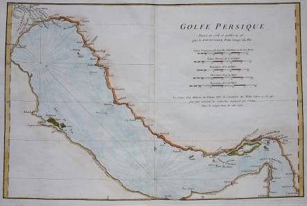
GOLFE PERSIQUE
Sold
Striking and highly attractive scarce 1776 map of the Persian Gulf by Jean Baptiste Bourguignon d'Anville. Essentially a nautical chart, this map covers from Basrah to the Straits of Hormuz. D'Anville prepared this map in 1758 to illustrate a lecture presented to the Paris Academie des Belles-Lettres regarding his speculations on the then little known geography of the Persian Gulf. Although the southwestern part of the Gulf is poorly mapped and little known, various Gulf cities are identified including Julfar (Ras al-Kahaimah), Mekehoan, Kalba, and Ras-ol Lima. The Qatar Peninsula is entirely absent, but the island of Bahrain is noted, though misaligned. The Saudi city of Qatif (el Katif) is however clearly identified. D'Anville was able to draw from Persian sources to map the northeastern shore of the Gulf and there the cartography is notably superior. D'Anville's sources for this map as well as his speculations are recorded in the La lecture d'un Memoire du Volume XXX, de l'Academie des Belles-Lettres, p. 132-197.
Very good condition
code : M3293
Cartographer : Jean Baptiste Bourguignon d'Anville
Date : 1776 Paris
Size : 30*44 cms
availability : Sold
Price : Sold
Jean Baptiste Bourguignon d'Anville (born in Paris July 11, 1697 – January 28, 1782), was both a geographer and cartographer who greatly improved the standards of map-making. His maps of ancient geography, characterized by careful, accurate work and based largely on original research, are especially valuable. He left unknown areas of continents blank and noted doubtful information as such; compared to the lavish maps of his predecessors, his maps