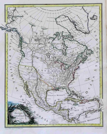
NORTH AMERICA AMERIQUE SEPTENTRIONALE
Sold
Charming early 19th century map of the continent depicting the newly acquired Louisiana Territory. The boundary between the United States and Canada is left undesignated although the outline coloring appears to claim the entire Pacific Northwest for Britain. Spain is shown in control of the present-day Southwest and Florida. Alaska is named "Amerique Russe". Attractive original coloured title cartouche. Engraved by Tardieu.
Very good condition.
code : M2259
Cartographer : LAPIE Pierre
Date : 1809 Paris
Size : 28.5*23cms
availability : Sold
Price : Sold
Pierre M. Lapie (fl. 1779 - 1850) and son Alexandre Lapie (fl. 1809 - 1850) were French cartographers and engravers active in the early part of the 19th century. Lapie (Pierre), cartographer, born at Mezieres in 1771, died in 1850, was admitted in 1794 to the corps of topographical engineers, in that capacity he made several campaigns, rose to the rank of Colonel of Staff, and in 1814 became director of the topographical cabinet of the king, was, from 1818 he was responsible for the direction of the new topographic map of France, and had the greatest part in the execution of this magnificent work. He published a classic Atlas (1812), which was improved in several successive editions, and a Universal Atlas of Ancient and Modern Geography (1828), one of the best of his era.