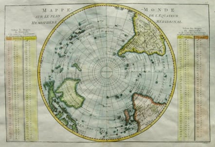
SOUTH POLE MAPPE-MONDE SUR LE PLAN DE L'EQUATEUR HEMISPHERE MERIDIONALE
Sold
Detailed map showing the Southern Hemisphere. Attractive 18th Century map published by Rigobert Bonne, the Royal Hydrographer. Bonne's atlas, which was issued in several editions, was one of the most commercially successful atlases of the 18th Century.
code : M2460
Cartographer : BONNE Rigobert
Date : 1780 Paris
Size : 24*35.5cms
availability : Sold
Price : Sold
Rigobert Bonne (1727-1795), a prolific French cartographer, was active between about 1760 and 1788, working in the French Hydrographical Office, and appointed as Hydrographer to the French King.
Bonne prepared a large number of charts, some of which appeared in the Atlas Maritime. Today, he is best known for the smaller maps that he prepared for Raynal’s Atlas de Toutes Les Parties Connues du Globe Terrestre, published in 1780, and the Atlas Encyclopedique, published in conjunction with Nicholas Desmarest. Although the maps are relatively plain, dispensing with the decorative embellishment of mid-century, they are detailed and provide good coverage of newly discovered regions.