CARTE DE L'HEMISPERE AUSTRAL
Sold
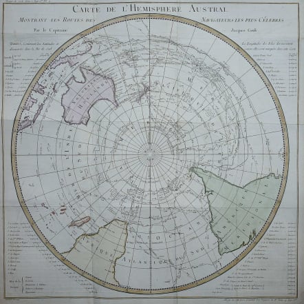
Attractive and important map of the southern seas and the navigators who sailed them.
This detailed chart is a French edition of Cook's voyage in the southern hemisphere that is drawn in a circular polar-projection. Lists beside the map provide details of discoveries and destinations in the southern hemisphere. Details include the routes of other explorers including Tasman, Dampierre, Carteret, Byron, Bougainville, Furneaux and others. The copper-engraved chart shows all of Australia (Nouvelle Hollande) with Tasmania attached to the mainland. There is good detail of the East Indies and the Celebes.
In addition to the map is a detailed set of tables of Latitudes and Discoveries, covering approximately 60 islands, bays, and other locales. A highly collectable map.
Good hand colour Pressed folds
Very good condition.
code : M3118
Cartographer : Jacques-Nicolas BELLIN
Date : 1780 Paris
Size : 54*54 cms
availability : Sold
Price : Sold
Jacques-Nicolas Bellin (1703-1772) was one of the most important and prolific French cartographers of the mid-eighteenth century, in the service of the French Hydrographical Office. He was appointed the first Ingenieur Hydrographe de la Marine, and also Official Hydrographer to the French King.
Bellin was responsible for an enormous output of charts and maps. In a large folio format, he issued a volume of sea-charts of France, the Neptune Francois, and several sea-atlases of the World, including the Atlas Maritime and the Hydrographie Francaise. These large charts were amongst the best of the period and continued being reissued throughout the second half of the eighteenth century.
In smaller format, he issued the Petit Atlas Maritime (1764),which contained 580 detailed charts, as well as maps to illustrate l'Abbe Prevost's Histoire Generale des Voyages (1746-1757). Bellin also produced a substantial number of important separately issued maps, particularly reflecting continuing discoveries and political events in the Americas.


