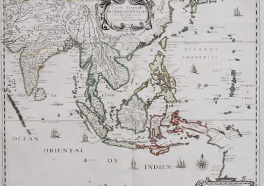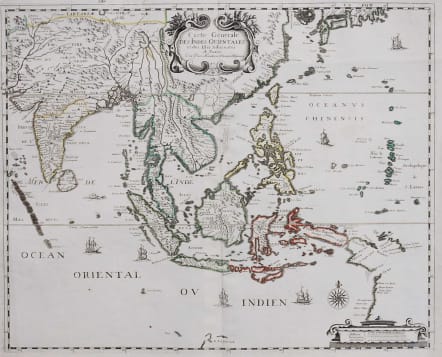
CARTE GENERALE DES INDES ORIENTALES ET DES ISLES ADIACENTES
£995
Superb and attractive early map of South East Asia from the Maledives to the South of Japan with parts of the northern Australian coast, published by Mariette
The map is derived from Henricus Hondius’ map of 1638. G. F. De Wids landt is identified in Western Australia, as is the Australian coastline below Papua New Guinea.
Early map showing the Dutch discoveries on Cape York and Western Australia based on either Blaeu’s or Hondius’s map, issued 1635 and 1638 but without a dedication cartouche at bottom left. Interestingly it includes the Trial Islands off the Western Australian coast which were to remain a mystery for nearly 200 years.
Pierre Mariette (1603-1657) was a partner and publisher with Nicolas Sanson d’Abbeville. From, 'Cartes Generales de Toutes les Parties du Monde.' This atlas is considered the first folio world atlas published in France.
Original outline colour.
Good impression.
Some 17thc annotation in margin not affecting map, otherwise
Excellent condition.
code : M3121
Cartographer : Pierre Mariette
Date : 1658 Paris
Size : 38.5*47 cms
availability : Available
Price : £995
Paris map maker and publisher , closely linked with sanson