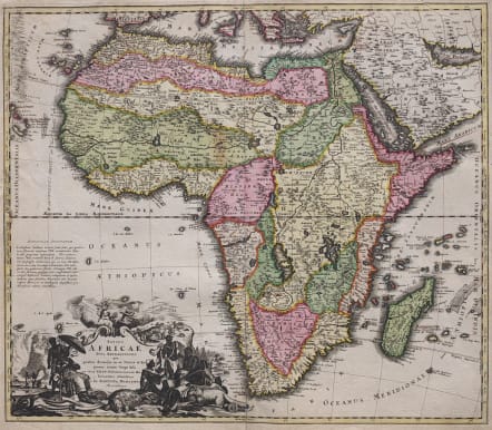
TOTIUS AFRICAE NOVA REPRESENTATIO ..
Sold
A very good example of Homann's scarce first map of Africa and certainly his most decorative.
Folio map of the continent with the typical inaccuracies of eighteenth century cartography. The map conforms to the twin lake configuration for the source of the Nile and a lengthy paragraph on the map purports to provide evidence of the accuracy of this theory based on the work of Heinrich Scherer. The geographical features are identical to the map that Johann engraved for Jacob von Sandrart, circa 1697, prior to Homann establishing his own publishing firm. The political boundaries and the large title cartouche are different. The cartouche is filled with interesting imagery including the pyramids, ivory trading, the source of the Nile, a troop of monkeys (throwing rocks at their hunters), kings, chiefs and warriors, a fat-tailed sheep with its tail supported by a wagon, and cherubs bringing salvation to the continent.
Good strong impression...Excellent original colour in fresh looking condition..
Very good condition.
code : M3306
Cartographer : Homann
Date : 1715 Nuremberg
Size : 49*57 cms
availability : Sold
Price : Sold
The Family HOMANN
Johann Baptist Homann (1664-1724) started his career in Amsterdam as an apprentice with the Danckerts family before returning to Nuremberg to establish himself in business in 1702. The firm quickly became the principal geographical publishers in Germany and in 1715 Homann was appointed Geographer to the Holy Roman Emperor and he was also a member of the Prussian Royal Academy of Sciences. His publications included the “Neuer Atlas Ueber Die Gantze Welt ...” in 1707-. The “Grosser Atlas ...” of 1716- and the “Atlas Novus Terrarum Orbis Imperioa” in c.1720, as well as many others. Johann died in 1724 and was succeeded by his son Johann Christoph who died in 1730. After his death the firm took the name Homann’s Heirs and continued thereafter until 1813. Publications with the Homann’s Heirs’ imprint included the “Grosser Atlas” in 1731, Doppelmays’r “Atlas Coelestis ...” in 1742 and the “Atlas Geographicus Maior ...” in 1753-, amongst others. Throughout this entire period the firm were the leading map publishers in Germany, employing a number of very important cartographers