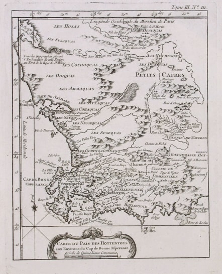
CAPE TOWN CARTE DU PAIS DES HOTTENTOTS
Sold
The scarce vertical Bellin map. Covers area from B.St Helena to Baye De La Chair. Marks Cape Colony and colonies of Stellenbosch and Drakensteen.with the native tribes ' the Goringaiconas,Gorachouquas of the Cape.Anchoarages,Compass rose etc.
Uncoloured as issued.Mint condition. .
.References Tooley ,Map Collectors Circle No 6 Early Maps of the Cape of Good Hope. Ref 21 Page 13
code : M2249
Cartographer : Jacques-Nicolas BELLIN
Date : 1764 Paris
Size : 22*18cms
availability : Sold
Price : Sold
Jacques-Nicolas Bellin (1703-1772) was one of the most important and prolific French cartographers of the mid-eighteenth century, in the service of the French Hydrographical Office. He was appointed the first Ingenieur Hydrographe de la Marine, and also Official Hydrographer to the French King.
Bellin was responsible for an enormous output of charts and maps. In a large folio format, he issued a volume of sea-charts of France, the Neptune Francois, and several sea-atlases of the World, including the Atlas Maritime and the Hydrographie Francaise. These large charts were amongst the best of the period and continued being reissued throughout the second half of the eighteenth century.
In smaller format, he issued the Petit Atlas Maritime (1764),which contained 580 detailed charts, as well as maps to illustrate l'Abbe Prevost's Histoire Generale des Voyages (1746-1757). Bellin also produced a substantial number of important separately issued maps, particularly reflecting continuing discoveries and political events in the Americas.


