KAART VAN BOMBAY CARTE DE BOMBAY
Sold
Plan de Bombay et de ses Environs Tire de Thornton Hyd. Ang.
Kaart van Bombay
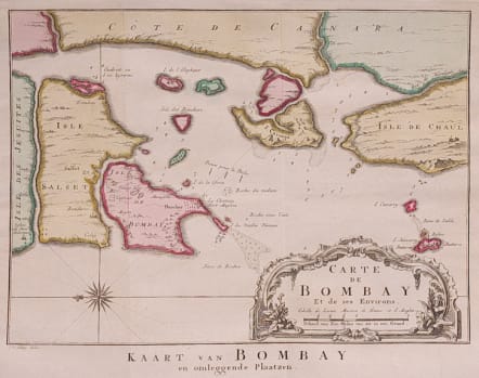
Rare plan of Bombay. There are very few maps of Bombay.
Very atractive Dutch issue map of the Bay of Bombay showing soundings, anchorages and fortifications. The map is based on the work of John Thornton, hydrographer of the British East India Company (1669-1701). Nicely engraved to show topography and decorated with a French style title cartouche and compass rose, which orients the map with north to the left.
Excellent hand colour.
Very good condition.
code : M4255
Cartographer : Jacques-Nicolas BELLIN
Date : 1750c Paris
Size : 19*26.5 cms
availability : Sold
Price : Sold
Jacques-Nicolas Bellin (1703-1772) was one of the most important and prolific French cartographers of the mid-eighteenth century, in the service of the French Hydrographical Office. He was appointed the first Ingenieur Hydrographe de la Marine, and also Official Hydrographer to the French King.
Bellin was responsible for an enormous output of charts and maps. In a large folio format, he issued a volume of sea-charts of France, the Neptune Francois, and several sea-atlases of the World, including the Atlas Maritime and the Hydrographie Francaise. These large charts were amongst the best of the period and continued being reissued throughout the second half of the eighteenth century.
In smaller format, he issued the Petit Atlas Maritime (1764),which contained 580 detailed charts, as well as maps to illustrate l'Abbe Prevost's Histoire Generale des Voyages (1746-1757). Bellin also produced a substantial number of important separately issued maps, particularly reflecting continuing discoveries and political events in the Americas.


