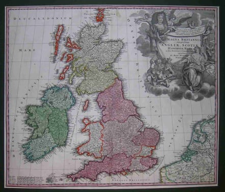
GREAT BRITAIN MAGNA BRITANNIA
Sold
Magna Britannia Complectens Angliae, Scotiae Et Hiberniae ... Homann's map of the British Isles has a complicated printing history, due in part to its popularity. The plate's history can be traced by the changes made to the elaborate title cartouche, which presides over the British Isles. This map is printed from the first of two plates that were used between c.1707 and the 1730s, and shows the portrait of Queen Anne. Two lines from Ovid above the portrait identify this example as the second state. Putti support the banner of dedication and the female form of Europe personified sits with a globe and open arms offering herself to Queen Anne. A very decorative and finely engraved map. Shirley, Printed Maps Of The British Isles, Homann 2. Excellent condition.ARCHIVED SOLDcode : M1110
Cartographer : Homann Family
Date : 90/ 1707-1713 Nuremberg
Size : 48.5*57.5cms
availability : Sold
Price : Sold
Johann Baptist Homann (1664-1724) started his career in Amsterdam as an apprentice with the Danckerts family before returning to Nuremberg to establish himself in business in 1702.
The firm quickly became the principal geographical publishers in Germany and in 1715 Homann was appointed Geographer to the Holy Roman Emperor and he was also a member of the Prussian Royal Academy of Sciences.
His publications included the "Neuer Atlas Ueber Die Gantze Welt ..." in 1707-. The "Grosser Atlas ..." of 1716- and the "Atlas Novus Terrarum Orbis Imperioa" in c.1720, as well as many others. Johann died in 1724 and was succeeded by his son Johann Christoph who died in 1730. After his death the firm took the name Homann's Heirs and continued thereafter until 1813. Publications with the Homann's Heirs' imprint included the "Grosser Atlas" in 1731, Doppelmays'r "Atlas Coelestis ..." in 1742 and the "Atlas Geographicus Maior ..." in 1753-, amongst others. Throughout this entire period the firm were the leading map publishers in Germany, employing a number of very important cartographers