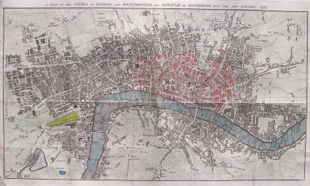
LONDON MAP A PLAN OF THE CITIES OF LONDON AND WESTMINSTER AND BOROUGH OF SOUTHWARK WITH THE NEW BUILDINGS 1767
Sold
Detailed uncommom map of London. INFO FROM MAPCO Publisher: Anonymous Date: 1767 Size: 54cm x 32cm (21" X 12¾") Scale: 4¼" : 1 statute mile Extent: New River Head - Shadwell - Newington Butts - Hide Park. Description: Folding plan printed on good heavy paper paper. Hand coloured. Title set in top margin. This 1767 London plan came from an American collector, who had erroneously attributed it to John Pine (1690-1756). It is cited in Howgego (No. 144) as Anonymous, and was most likely published in The Gentleman's Magazine (first published in 1731 by Edward Cave), The Universal Magazine of Knowledge and Pleasure (first published 1740), or similar publication. I am under the impression that T.Kitchen was the engraver. Folds as issued.V.good condition SOLDcode : M1707
Cartographer : KITCHIN Thomas
Date : 9000/ 1767
Size : 50*30cms map not plate mark
availability : Sold
Price : Sold
Thomas Kitchin (1718-1784) was one of the best and most prolific engravers of the eighteenth century. He issued The General Atlas, Describing the Whole Universe , first published in 1773, and regularly reissued thereafter. His work also included a large number of maps of the English counties, particularly for the London Magazine (1747-1760), the Universal Magazine (1747-1766), and for Dodsley’s England Illustrated (1764). Other maps were published in conjunction with Emanuel Bowen in the Large English Atlas and the Royal English Atlas (1763).