LONDON PLAN OF THE CITIES OF LONDON AND WESTMINSTER
Sold
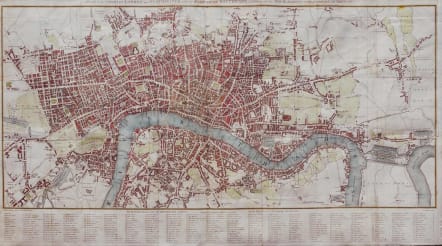
Title Plan of the Cities of London and Westminster, with the Borough of Southwark, exhibiting all the New Buildings to the Present Year MDCCCVI
Very attractive and uncommon large plan of London.
Antique map of London, engraved by Neele for Lambert's 'History and Survey of London'. Samuel Neele important London map engraver 1758-1824. Map covers the area : Knightsbridge, Pentonville, the East India Docks and Newington Butts. This is the second state, … read morewith grid and key of streets. Of interest is an entry "Oliver Cromwells Castle" at the bottom of the map at the centrefold: this was a star fort built by the Parliamentarians as part of the city defences during the Civil War. It is known to have survived until the end of the 18th century.
Excellent hand colour.
Very good condition.
Ref: HOWGEGO: 236.
Neele Ref British MapEngravers L. Worms p. 482
code : M2684
Cartographer : Neele
Date : 1806 London
Size : 42*72 cms
availability : Sold
Price : Sold


