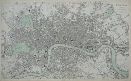
LONDON 1843
Sold
Drawn & engraved from authentic documents & personal observation by B.R. Davies, 16 George Street, Euston Square. London, published Nov. 1, 1843 under the superintendence of the Society for the Diffusion of Useful Knowledge, by Chapman & Hall, 186 Strand (1844)
Superb large detailed map of LOndon. Beautifully engraved.
It extends from Hoxton to the East India Docks, and Walworth to Hammersmith. This map extends westwards to incorporate the newly developed areas of Kensington, Chelsea, Notting Hill, Paddington and Maida Vale.
Original colour.
Mint condition
Ref http://www.davidrumsey.com/maps3872.html
code : M2908
Cartographer : S.D.U.K
Date : 1843 London
Size : 39*65 cms
availability : Sold
Price : Sold
The Society For The Diffusion Of Useful Knowledge was founded by John, Earl Russell, and Henry Brougham, later Lord Chancellor of England in 1827. The Society’s main purpose was to encourage universal literacy by publishing numbers of books of good quality that would be affordable to the poor. Perhaps the grandest of their publications was their atlas, originally entitled “Maps Of The Society For The Diffusion Of Useful Knowledge”, first issued by Baldwin and Cradock, and then re-issued by other publishers, latterly Edward Stanford.