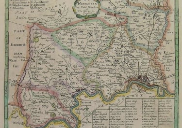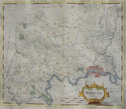
MIDLESEX BY ROBT MORDEN
£150
This map of Middlesex is an early county map to show the county’s roads. It presents a good view of the city of London and the Thames River along with the locations of towns, buildings, forests, rivers, bridges and parks, which are noted by fenced areas. There is a decorative cartouche and three different distance scales. Sold by Abel Swale, Awnsham & John Churchil.
Morden was one of the first English cartographers to show longitudes measured from the meridian of St. Paul's Cathedral (shown in degrees at the bottom of the map) and time in minutes measure locally from the sun (shown at the top). The roads on his maps are based on Ogilby's earlier survey. The Britannia was first published by historian William Camden (1551-1623) in 1586. After the publication of the final edition of Britannia in 1637, the work was not published again until 1695 when Gibson revised and translated the text from the original Latin and included fifty maps, mostly of the English counties, prepared by Robert Morden, replacing the outdated maps of Christopher Saxton. This map is from the subsequent edition of 1722.
Good hand colour
Very good condition.
WAS 225 SALE PRICE £150 Christmas 2021
code : M3390
Cartographer : Robert Morden
Date : 1722 London
Size : 37*42 cms
availability : Available
Price : £150
Considering the popularity and success of Camden’s “Britannia”, first issued with maps in 1607, it is surprising that it was not until the end of the seventeenth century that a new edition was prepared. Robert Morden (d.1703) was commissioned to engrave a set of county maps for this new edition by Edmund Gibson. However, the first series he prepared were rejected as being too small, and these were later published in Morden’s “New Description and State of England”, first issued in 1701, and subsequently re-issued in Cox’s “Magna Britannia”, in the 1720s.
Morden finally produced a new set of maps on a larger scale which were used in Gibson’s editions published in 1695, 1722, circa 1730, 1753 and 1772. The maps were based on the most up-to-date surveys where available, although some drew on Saxton and Speed, and were engraved by Sutton Nicholls and John Sturt.