
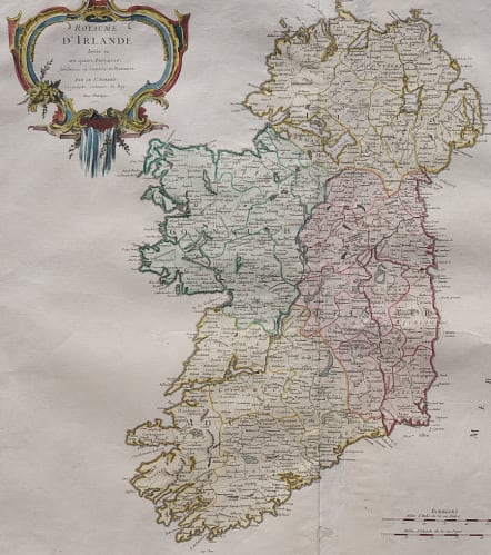


ROYAUME D'IRLANDE DIVISEE EN SES QUARTRES PROVINCES
£195
Good large folio map of Ireland. Much detail including mountains, rivers, town, forests etc.
Decorative title cartouche
Strengthening on centre fold at back and small unobtrusive repair
Excellent full wash colour.
Overall good condition for this large attractive map of Ireland
code : M4960
Cartographer : VAUGONDY ROBERT DE Family
Date : 1750 Paris
Size : 48.5 x 54.5 cms
availability : Available
Price : £195
The Robert de Vaugondy family responsible for map and globe publishing in Paris comprised Gilles Robert de Vaugondy (1688-1766) and Didier Robert de Vaugondy (1723-1786). The father (Gilles) and son (Didier) business flourished from 1731 to 1778.
Prominent at this time among French map-makers were the Robert de Vaugondy family, who made a substantial contribution to the eighteenth century world of cartography, through the breadth and success of their prolific output, which included atlases, maps, globes and book illustration.
While only a small part of their output, the "Atlas Universel" encapsulates the diligent and scientific approach adopted by the Roberts de Vaugondy, and proved to be the most successful French world atlas of the period. It appeared from c.1757 onwards.


