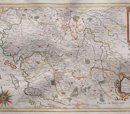

CARTE GENERALE DE POICTOU XAINTONGE ANGOULMOIS ET PAYS D'AULNIX
Sold
Very attractive and detailed folio map of the area north of the river Gironde depicting Poitou and Saintonge. Showing Poitiers, Limoges, Nantes, La Rochelle and also Bouin, Noirmoutier, Dieu, Ré and Oléron islands.
Embellished with a title cartouche, a scale cartouche, a beautiful wind rose and several sailing ships.
Nicolas Tassin, who was active from 1633 till 1655, was appointed 'royal cartographer' at Dijon before setting up as an engraver in Paris where he issued various collections of small maps and plans of France, Switzerland, Germany and Spain.
Maps by Tassin in original colours are very rare. Early impression without the plate number 11 in upper right corner.
V good original colour
Excellent condition
Reference: Pastoureau, Tassin II A.
h
code : M3625
Cartographer : Nicolas Tassin
Date : 1634 Paris
Size : 37*51 cms
availability : Sold
Price : Sold
TASSIN, Nicolas
fl. 1633 - 1655
Tassin was appointed 'royal cartographer' at Dijon before setting up as an engraver in Paris where he issued various collections of small maps and plans of France, Switzerland, Germany and Spain.