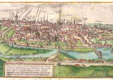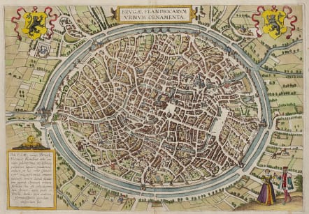
BRUGAE FLANDRICARUM URBIUM ORNAMENTA
Sold
Superb town plan by Braun & Hogenberg from the 'Civitates Orbis Terrarum'.
Commentary by Braun: "Bruges is said to have acquired its name from its great number of bridges. It has a marketplace adorned on all sides by magnificent houses, from which six wide streets lead away to the city gates. It has access to the sea, which lies three miles away; numerous streams and navigable channels run through the city. In later times its wealth diminished, partly because the water receded but partly, too, because the Hanseatic merchants left the city."
TRANSLATION OF CARTOUCHE TEXT (Bottom left): Brugae, generally known as Bruck, is the most beautiful and elegant of all German cities in Flanders. The splendour and magnificence of the public and private buildings in this city surpass all imagination and description. It possesses the best ground plan imaginable - one that is circular. It is surrounded by a double moat filled with water. It was formerly a flourishing city of commerce.
Excellent later hand colour
Very good condition
REF References: Taschen, Braun and Hogenberg, p. 73.
code : M4844
Cartographer : BRAUN & HOGENBERG
Date : 1572c
Size : 32*46 cms
availability : Sold
Price : Sold
Georg Braun (1541-1622) and Frans Hogenberg (1535-1590) were co-publishers of the monumental Civitates Orbis Terrarum, “the earliest systematic city atlas” (Koeman), published from 1572 onwards. Designed as a companion to Ortelius’ world atlas the Theatrum, this enormous work, which was expanded to six volumes by 1617 incorporating over 500 plans and views, must be viewed as one of the most ambitious book producing ventures of all time, and certainly, with Ortelius’ Theatrum and Blaeu’s Atlas Maior among the greatest achievements in the history of cartography.
Braun compiled the accompanying text, printed on the reverse of the engraved sheets, while the plans were engraved by Hogenberg, who had also prepared some of the maps for Ortelius’ Theatrum. Hogenberg used generally up-to-date and accurate maps, surveys and reports from local sources to compile this collection of plans and bird’s-eye views of all the major towns of Europe, some African, Middle Eastern and Indian towns, and the New World cities of Mexico and Cusco. One of the major contributors was Georg (or Joris) Hoefnagel, who supplied some 63 manuscript drawings, the vast majority from personal observation.