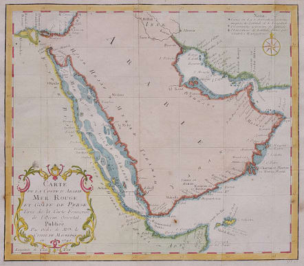
CARTE DE LA COSTE D' ARABIE
Sold
Attractive map focusing on the Red Sea, also covering coastal areas around the Arabian Peninsula and the Persian Gulf. Jacques Bellin was Hydrographer in the French Dépôt de la Marine; with access to the latest navigational reports, he produced a great many maps and charts of excellent quality. Here, despite the small-scale, we see good detail of island, shoals and banks along the coasts. In the best tradition of scientific cartography, Bellin notes the methods by which several locations on the map have been ascertained, whether by astronomical or other, less accurate observations.
Good hand colour.
Very good condition.
code : M4252
Cartographer : Jacques-Nicolas BELLIN
Date : 1740 Paris
Size : 23*26cms
availability : Sold
Price : Sold
Jacques-Nicolas Bellin (1703-1772) was one of the most important and prolific French cartographers of the mid-eighteenth century, in the service of the French Hydrographical Office. He was appointed the first Ingenieur Hydrographe de la Marine, and also Official Hydrographer to the French King.
Bellin was responsible for an enormous output of charts and maps. In a large folio format, he issued a volume of sea-charts of France, the Neptune Francois, and several sea-atlases of the World, including the Atlas Maritime and the Hydrographie Francaise. These large charts were amongst the best of the period and continued being reissued throughout the second half of the eighteenth century.
In smaller format, he issued the Petit Atlas Maritime (1764),which contained 580 detailed charts, as well as maps to illustrate l'Abbe Prevost's Histoire Generale des Voyages (1746-1757). Bellin also produced a substantial number of important separately issued maps, particularly reflecting continuing discoveries and political events in the Americas.


