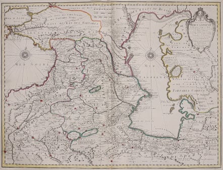
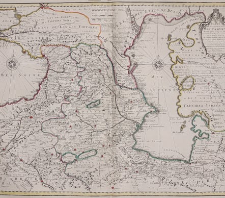

CARTE DES PAYS VOISINS DE LA CASPIENE
Sold
Stunning map of the Caucuses. Covering the area from the Black Sea to Tartary and from Russia to Persia, ithe Caspian Sea, and Georgia, Armenia, Azerbaijan, Kazakhstan, Turkmenistan, Iran, and Turkey.
Very important map and the most detailed map of the region so far produced in 1720.
The Caspian Sea was not mapped accurately until the Russian Carl Verden surveyed it in 1722. It was De L'Isle who first published Verden's map: this version places the new information into the general map of the area. So useful for trade and diplomacy in the eighteenth century.
This is the Covens & Mortier issue of the De L'Isle map.
Cartouche, compass roses Original outline colour ..Beautiful map recommended.
Mint condition
code : M3705
Cartographer : COVENS & MORTIER
Date : 1730c Amsterdam
Size : 47*61 cms
availability : Sold
Price : Sold
The Amsterdam publishing firm of Covens and Mortier (1721 - c. 1862) was the successor to the extensive publishing empire build by Frenchman Pierre Mortier (1661 - 1711). Upon Mortier's death in 1711 his firm was taken over by his son, Cornelius Mortier (1699 - 1783). Cornelius married the sister of Johannes Covens (1697 - 1774) in 1721 and, partnering with his brother in law, established the Covens and Mortier firm. Under the Covens and Mortier imprint, Cornelius and Pierre republished the works of the great 17th and early 18th century cartographers De L'Isle, Allard, Jansson, De Wit, and Ottens among others. The quickly became one of the largest and most prolific Dutch publishing concerns of the 18th century