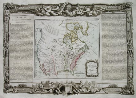
NORTH AMERICA NOUVEAU MEXIQUE,LOUISIANE,CANADA ET NLLE ANGLETERRE
Sold
The highly detailed North America map from Brion de la Tour's Atlas General, Civil, et Ecclesiastique, from Baffin's Bay to Central Mexico. The sketchier mapping of the West Coast is based on Russian sources, published in St. Petersburg in 1754. The map, in delicate outline color, is surrounded on both sides by text on the discovery and history of the French, Spanish, and English territories in North America.
Very good condition
*The map shows the extent of discoveries in the Southwest, Alaska and the Arctic Regions. Two long rivers run from California to the Rocky Mountain region, the Northernmost attaching Lake Winnepeg. Extensive note regarding explorations along the NW Coast of America, but the Sea of the West has given was to the Decouvertes Des Russes. The Mississippi River drainage is now well explored by the French, who are now shifing west following the end of the French & Indian War. A number of French forts shown, including Detroit, S. Pierre, S. Charles, S. Phillipe, Huillier, S. Francisco, and Rosalie
code : M2385
Cartographer : Louis Brion de la Tour
Date : 1766 Paris
Size : 39*54cms
availability : Sold
Price : Sold
Louis Brion de la Tour (1756-1823) was the Cartographer Royal to the King of France.
There is little information about his life. His official title was "King's Engineer Geographer." Although he is a prolific geographer, very little is currently known of his life or his career. His life was spent in scientific work. However what is known is an important part of his work was done in collaboration with Louis Charles Desnos (1750-1790 to) a bookseller and geographical engineer for the globes and spheres of His Danish Majesty.
His son Louis Brion de la Tour, a pupil of Jean-Bernard Restout, was engraver of maps and documents of the Revolution, and was also an occasional portrait oil paintings.