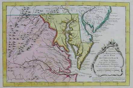
VIRGINIA CARTE DE LA VIRGINIE ET MARYLAND OU DE LA BAIE DE CHESAPEACK
£250
Rare in full original colour.
A map of Virginia, Maryland and the Chesapeake Bay by Jacques Nicolas Bellin, the Hydrographer to the King of France. From about 1650 to 1750, the French dominated the cartographic world, with their fine, scientifically based maps, elegantly engraved and precisely detailed. Bellin (1703-72) was one of the best in the later period. This map focuses on the Chesapeake Bay, showing the rivers and creeks draining into it and the towns and roads throughout the area. Also shown are the southern parts of Pennsylvania (including Philadelphia) and New Jersey. A lovely baroque title cartouche compliments this historic interest of this map.
Very good condition.
code : M2470
Cartographer : Jacques-Nicolas BELLIN
Date : 1758 Paris
Size : 19.5*29cms
availability : Available
Price : £250
Jacques-Nicolas Bellin (1703-1772) was one of the most important and prolific French cartographers of the mid-eighteenth century, in the service of the French Hydrographical Office. He was appointed the first Ingenieur Hydrographe de la Marine, and also Official Hydrographer to the French King.
Bellin was responsible for an enormous output of charts and maps. In a large folio format, he issued a volume of sea-charts of France, the Neptune Francois, and several sea-atlases of the World, including the Atlas Maritime and the Hydrographie Francaise. These large charts were amongst the best of the period and continued being reissued throughout the second half of the eighteenth century.
In smaller format, he issued the Petit Atlas Maritime (1764),which contained 580 detailed charts, as well as maps to illustrate l'Abbe Prevost's Histoire Generale des Voyages (1746-1757). Bellin also produced a substantial number of important separately issued maps, particularly reflecting continuing discoveries and political events in the Americas.


