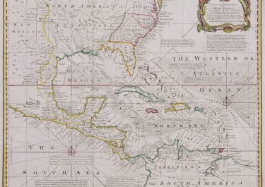
A NEW MAP OR CHART OF THE WESTERN OR ATLANTIC OCEAN WITH PART OF EUROPE AFRICA & AMERICA *
Sold
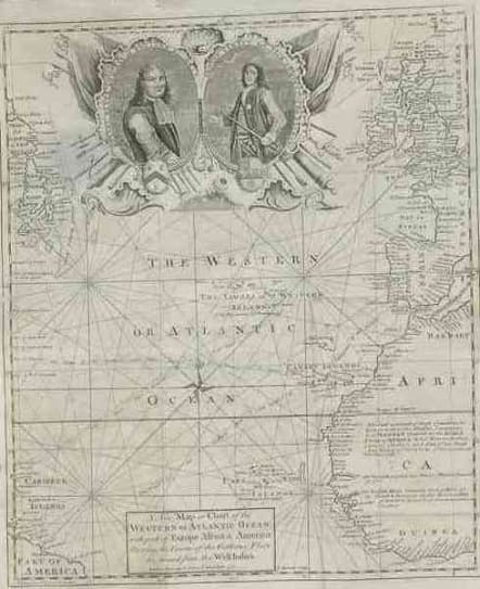
Rare map of the Atlantic from Europe and West Africa to Parts of the Americas.Chart published a year after the start of the war with Spain.Shows the track of Galleons from West indies to Spain and Britain,It celebrates Vernons successes at Portobello & Cartagena and refers back to Blakes action against the Spanish treasure galleons.The cartouche contains a double portrait of Robert Blake q& Edward Vernon surrounded by flags & instruments of war.A wealth of detail.Remargined on left with no loss of map.good condition.
code : M571
Cartographer : Emanuel BOWEN
Date : 1740 London
Size : 35*29.5cms
availability : Sold
Price : Sold
Emanuel Bowen (c.1693/1694-1767) was an English engraver, publisher and mapseller active in London between 1720 and 1767. His prolific output as engraver and publisher earned him recognition both in England and France, for he held the dual appointment of Engraver to George II and to Louis XV of France.
Bowen engraved large numbers of maps for general atlases, geographical text-books and periodicals, particularly The Complete System of Geography, the Universal History of the World, the small-format periodical The General Magazine of Arts and Sciences and the Complete Atlas.
Bowen also produced a large number of English county maps. His earliest known publication was a series of road maps of England and Wales, the Britannia Depicta, with a map of each county, produced in partnership with John Owen in 1720 (the Owen and Bowen maps). This series was very popular, being frequently re-issued up to 1764 and was the most successful successor to John Ogilby's renowned road book.