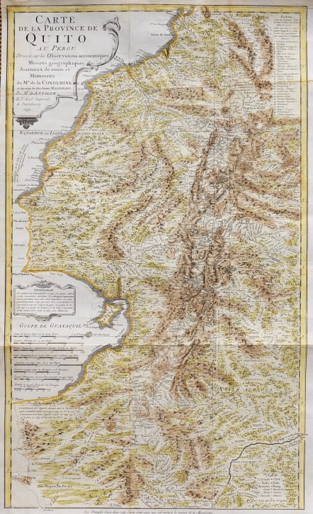


CARTE DE LA PROVINCE DE QUITO AU PEROU
£275
Superb detailed map titled 'Carte de la Province de Quito au Perou'.
Detailed map of Ecuador and Peru, with details of the province of Quito. This map covers parts of modern day Colombia, Ecuador, and Peru. It stretches from Barbacoas, Colombia in the north, south past Quito and Guayaquil, Ecuador, into central Peru, and from the Pacific coast into the interior.
Detail include mountains, towns,volcanos including Cotopaxi and rivers.
Incliudes the Geodesic Mission shows the length of a one degree of meridian at the equator near and centered on Quito, The High Andes encompassing the Volcanos and in fact the highest point on earth to the stars ( due to the equatorial bulge).
See my rare map
https://www.maphouse.co.uk/antique-maps/south-america/M4556-scarce-map-of-ecuador-and-the-triangulation/
Excellent hand colour
Very good condition
Published by Bellin Paris 1751
This map originates from 'Journal du voyage fait par ordre du roi à l'équateur (..)' by Charles Marie de la Condamine.
code : M4751
Cartographer : ANON
Date : 1751
Size : 35*59 cms
availability : Available
Price : £275