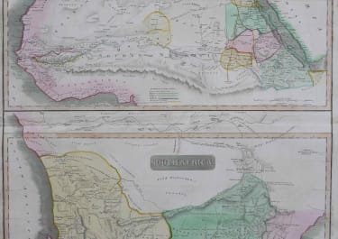
SOUTH AFRICA NORTH AFRICA
£85
Pair of detailed maps on one sheet engraved for Thomson’s "New General Atlas". Dated in the plate 1815.
Original hand colour.
Very good condition.
As the South Africa part is of particlar interest the map can be folded for framing so showing only the South Africa part.
code : M2803
Cartographer : John Thomson
Date : 1805 London
Size : 60*52 cms
availability : Available
Price : £85
THOMSON, John
flourised 1814-1869
John Thomson produced two major works in his life time, A New General atlas of the World 1814-28 and Atlas of Scotland 1820-32. The maps from A New General atlas of the World were printed in full hand coloring from large copperplate engravings. The level of detail at the time of publication was heralded as a breakthrough in British cartography and Thomson rightly earned a great deal of attention and his work copied for a number of years