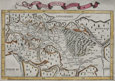
TABU PROVI RHENI FRIES
£650
THE RHINELAND AND ALSACE
Very attractive, early woodcut map of southwestern Germany depicting the Black Forest region and Rhine River valley along the German borders with France and Switzerland.
Cities marked include Strasbourg, Heidelburg and Frankfurt.
One of the earliest available maps of the region.
Second edition (of four) of this map based on Waldseemüller's modern map of Rheinland-Pfalz.
Recto is a map of Lorraine ( 33.5 x 23 cm. ) and . text contained within elaborate Renaissance woodcut panels which may have been designed by Albrecht Dürer, the known contributor to diagrams elsewhere in the atlas.
Excellent hand colour
Mint condition
code : M5278
Cartographer : Fries Waldseemuller Ptolomy
Date : 1525
Size : 30*43 cms printed area inc title
availability : Available
Price : £650
Early Ptolomaic map publishers and cartographers