NEWFOUNDLAND AND NOVA SCOTIA
£125
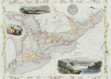
Attractive and detailed engraved map with vignettes of St. Johns, and steam and sailing ships in the Cod Fishery off Newfoundland. This is the earlier edition without the provincial seals. Decorative border.
Original outline colour
Vignettes later hand colour
Very good condition.
code : M5161
Cartographer : Tallis John
Date : 1845 London
Size : 25.5*32.5 cms
availability : Available
Price : £125
TALLIS, John
active 1838-1851
John Tallis founder of Tallis and Co., London map publishers who traded under various names: L. Tallis, Tallis & co, John Tallis, John Tallis & co. (London & New York) between 1838 and 1851. After 1850-51, their maps were published by the London Printing and Publishing Co., London and New York.
The Illustrated Atlas of the World, published in 1849 with the maps and decorative vignette's engraved and drawn by J. Rapkin, was one of the last atlases to be truly decorated and is therefore highly prized.