


CARTE DE LA VIRGINIE ET DU MARYLAND FRY & JEFFERSON PUBLISHED BY VAUGONDY 1755
£1200
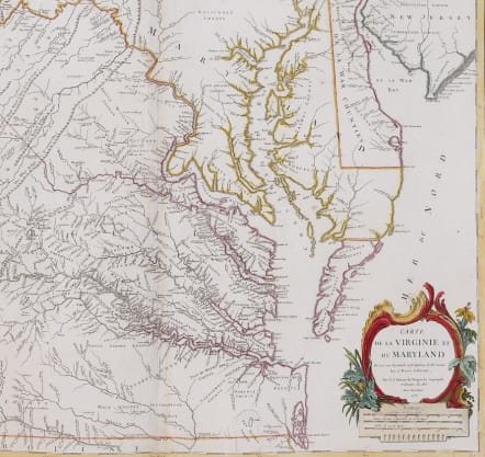
Stunning map of Virginia & Maryland; this is the first single sheet map ( taken from the 4 sheet map published in London in 1751)and first French map incorporating mapping work of Joshua Fry and Peter Jefferson.
This beautiful single folio sheet example of the most sought after and recognizable 18th Century map of Virginia and Maryland. While the title is in French, virtually all of the place names and annotations are in English. The map provides a fabulously detailed look into pre-revolutionary war Virginia and Maryland, extending west to the Alleghany Mountains, and including Delaware and a portion of New Jersey, as well as the region around Philadelphia.
Originally prepared by Joshua Fry of William & Mary and Peter Jefferson (father of President Thomas Jefferson) at the request of Lord Halifax in 1748.
Thomas Jefferson, son of Peter, hung the Vaugondy map at Monticello because the English edition of his father’s map was too large.
Original outline colour supplemented later.
Excellent condition * Recommended
**By the middle of the 18th-century there was an urgent need for a new and accurate map of the colony of Virginia. "To resolve the crisis, the Board of Trade and Plantations in London instructed acting governor Lewis Burwell to appoint 'the most proper and best qualified' surveyors to compile the needed map. Burwell, turned to Albermarle County surveyor, Joshua Fry, and deputy surveyor, Peter Jefferson, to create the new map. Fry and Jefferson were ideal choices ... [as they had already accumulated a great deal of first-hand knowledge about the area to be mapped.] They finished their manuscript in the summer of 1751" (Stephenson & McKee p.83). The first issue of the map appeared in 1753-4 and it was revised and re-published in 1755. This re-issue became "the preeminent map of Virginia for the remainder of the eighteenth century" and is the first map to depict the general whereabouts of the Appalachian and Allegheny mountains as well as being the map on which the present example is based. Following the original mapping, several French editions were issued, including the present map by Vaugondy.
Phillips Atlases 619. Swem 184. Pedley 470, State 1. ..
Stephenson & McKee p.83 II-21A-D
code : M5213
Cartographer : VAUGONDY ROBERT DE Family
Date : 1755 Paris
Size : 49*66 cms to plate mark sheet 52*79 cms
availability : Available
Price : £1200
The Robert de Vaugondy family responsible for map and globe publishing in Paris comprised Gilles Robert de Vaugondy (1688-1766) and Didier Robert de Vaugondy (1723-1786). The father (Gilles) and son (Didier) business flourished from 1731 to 1778.
Prominent at this time among French map-makers were the Robert de Vaugondy family, who made a substantial contribution to the eighteenth century world of cartography, through the breadth and success of their prolific output, which included atlases, maps, globes and book illustration.
While only a small part of their output, the "Atlas Universel" encapsulates the diligent and scientific approach adopted by the Roberts de Vaugondy, and proved to be the most successful French world atlas of the period. It appeared from c.1757 onwards.


