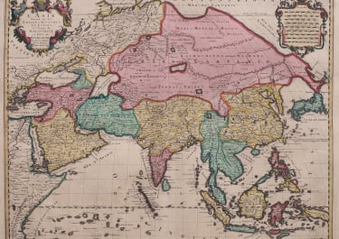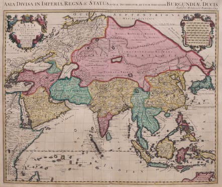
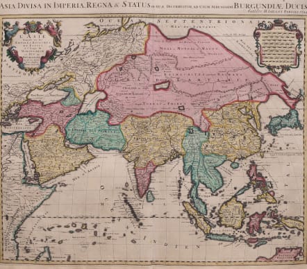
ASIA DIVISA IN IMPERIA
£950
Full Tite above map : Asia Divisa in Imperia, Regna & Status in que distribuitur, ad usum serenissimi Burgundiae Ducis
Title in cartouche; L'Asie divisee en ses Empires Royaumes et Estats a L'Usage de Monsieigneur Le Duc De Bourgogne ;;
Stunning fresh looking original hand colour .. (best Ive seen.)
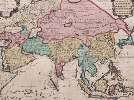
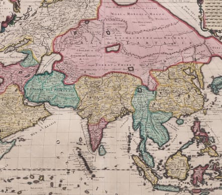
An attractive and scarce map of Asia based on the Sanson-Jaillot map of 1692, with the now obsolete delineation of Siberia and Japan. The island of Hokkaido is attached to the mainland as part of the Yupi peninsula. An incomplete coastline appears to the east, labeled both Terre de Iesso Ieco and Terre de la Compagnie. Korea appears as an elongated peninsula, and the mythical Lac de Chiamay is shown as the source of five major rivers west of China. The map is updated to include the northern coastline of Australia (Nouvelle Hollande) based on the Delisle configuration of 1705. The upper corners contain decorative cartouches with a dedication to the Duc de Bourgogne and a scale of miles cartouche.
Excellent fresh looking original hand colour
Very good condition for this scarce edition
code : M5525
Cartographer : JAILLOT & COLLABORATORS
Date : 1694 Paris
Size : 50*59 cms sheet size 53*63 cms
availability : Available
Price : £950
JAILLOT and reissues
Alexis Hubert Jaillot (c.1632-1712). In 1664 he married Jeanne Berey, the daughter of Nicolas Berey, the map publisher, and following the death of his father-in-law and his brother-in-law (also Nicolas), the business passed to Jaillot and he was to gain access to much of the stock.
On the death of Nicolas Sanson, his firm passed to his sons Guillaume and Adrien. They took Alexis Hubert Jaillot into partnership in 1671, now well-established at 'Aux Deux Globes', and he was to become second only to Sanson himself among the early school of French cartographers.
A number of Sanson's maps had been prepared but never published and others were in need of revision, so Jaillot began the process of preparing new maps on larger plates. These were published in the "Atlas Nouveau", published from 1681 onwards, although individual maps date from 1672.
After the break-up of his partnership with the Sansons, Jaillot joined with the Amsterdam publisher Pierre Mortier, who engraved virtually identical copies of these large maps, re-issued from 1692 onwards. In a similar vein, Mortier also copied the maps from Jaillot's "Atlas Francois" to be re-issued by him in the "Atlas Royal".
These Jaillot atlases, both in the French and Dutch versions, mark the end of the dominance of the flamboyant Dutch school of cartography, which was superseded by the more scientifically based French school. Jaillot exemplified the scientific approach of the French school, which was to reach full maturity in the next century under Guillaume de l'Isle and his heirs, and Jean Baptist d'Anville, who established France as the centre of European cartography.