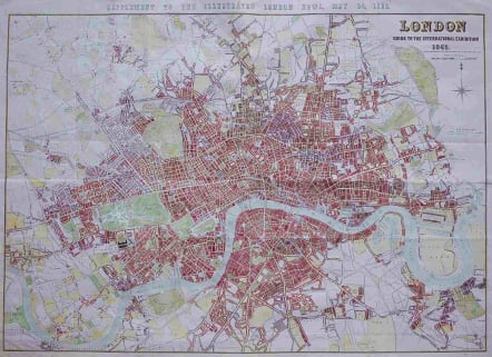
LONDON GUIDE TO THE INTERNATIONAL EXHIBITION 1862
Sold
Superb large map of London.
This very large and impressive plan of London was published specifically for the city's international exhibition of 1862. The exposition was a world's fair, seven years after the Exposition in Paris.
It provides remarkable detail of London's streets, landmarks, docks and other places of interest. Locates all parks, botanical gardens and scores of buildings of import. An extremely fine example of this large-scale engraved work.
The map covers the area from Highgate in the north, to Stockwell in the south, and from Poplar in the east, to Hammersmith in the west.
The map shows the International Exhibition in Cromwell Road in the grounds of the, then, Royal Horticultural Society's Gardens. The South Eastern Railway's extension to Charing Cross is shown in progress.
Importantly this was the first up-to-date map of Central London for over a decade.
Excellent hand colour.
Highly recommended ...
code : M3186
Cartographer : John DOWER
Date : 1862 London
Size : 76*108 cms
availability : Sold
Price : Sold
Engraver worked for William Orr publisher

