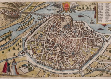

MARSEILLE
£395
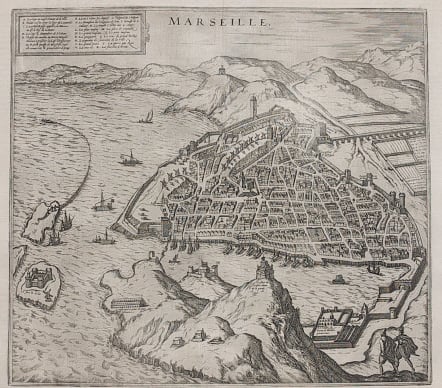
Beautiful birds eye plan of the oldest city in France, probably derived from Sebastian Munster's similar plan. The harbor is defended by three large forts, with a floating gate guarding the harbor entrance. The city is dominated by the 12th century cathedral and a cartouche at top contains the key to the major buildings. Levantine trading ships are shown in the surrounding sea and harbor, and people are shown seine fishing from an offshore island.
Uncoloured as originally issued.
An excellent example of one of the most decorative early city plans.
Ref: Goss (City) #33.
code : M3550
Cartographer : BRAUN & HOGENBERG
Date : 1575 Cologne
Size : 32*35 cms
availability : Available
Price : £395
Georg Braun (1541-1622) and Frans Hogenberg (1535-1590) were co-publishers of the monumental Civitates Orbis Terrarum, “the earliest systematic city atlas” (Koeman), published from 1572 onwards. Designed as a companion to Ortelius’ world atlas the Theatrum, this enormous work, which was expanded to six volumes by 1617 incorporating over 500 plans and views, must be viewed as one of the most ambitious book producing ventures of all time, and certainly, with Ortelius’ Theatrum and Blaeu’s Atlas Maior among the greatest achievements in the history of cartography.
Braun compiled the accompanying text, printed on the reverse of the engraved sheets, while the plans were engraved by Hogenberg, who had also prepared some of the maps for Ortelius’ Theatrum. Hogenberg used generally up-to-date and accurate maps, surveys and reports from local sources to compile this collection of plans and bird’s-eye views of all the major towns of Europe, some African, Middle Eastern and Indian towns, and the New World cities of Mexico and Cusco. One of the major contributors was Georg (or Joris) Hoefnagel, who supplied some 63 manuscript drawings, the vast majority from personal observation.