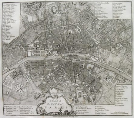
PARIS A PLAN OF THE CITY OF PARIS
Sold
A handsome and finely engraved plan of Paris based on late 18th century information. The work contains three legends identifying 78 points of interest, including major landmarks.
A decorative cartouche is located in the lower portion of the plate.
Very good condition.
Ref: Les Plans De Paris,Jean Boutier Ref 300
code : M2381
Cartographer : STOCKDALE John
Date : 1771/ 1800 London
Size : 23.5*26.5cms
availability : Sold
Price : Sold
John Stockdale (March 25, 1750 - June 21, 1814) was an English book and map publisher active in London in the late 18th and early 19th centuries.
Stockdale had a number of important works to his name, including several geographies, most notably the 1794 American Geography 1794 and, with John Cary, the 1805 New British Atlas