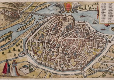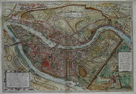
LYON LUGDUNUM
Sold
From Civitates Orbis Terrarum.
BRAUN: "Lyons has very beautiful houses and well-tended gardens. In wealth it exceeds all other cities in the whole of Romandy. The reason for this wealth is the rivers, because they lie near major cities. Since Lyons is situated in the middle of Europe and hence is called the heart of the Welschland, these rivers offer the best means of exporting and importing all interesting kinds of goods from the most lands in Europe."
Original colour a little faded..Good condition.
References: Taschen, Braun and Hogenberg, p.64.
code : M2183
Cartographer : BRAUN & HOGENBERG
Date : 1575 Cologne
Size : 34*48cms
availability : Sold
Price : Sold
Georg Braun (1541-1622) and Frans Hogenberg (1535-1590) were co-publishers of the monumental Civitates Orbis Terrarum, “the earliest systematic city atlas” (Koeman), published from 1572 onwards. Designed as a companion to Ortelius’ world atlas the Theatrum, this enormous work, which was expanded to six volumes by 1617 incorporating over 500 plans and views, must be viewed as one of the most ambitious book producing ventures of all time, and certainly, with Ortelius’ Theatrum and Blaeu’s Atlas Maior among the greatest achievements in the history of cartography.
Braun compiled the accompanying text, printed on the reverse of the engraved sheets, while the plans were engraved by Hogenberg, who had also prepared some of the maps for Ortelius’ Theatrum. Hogenberg used generally up-to-date and accurate maps, surveys and reports from local sources to compile this collection of plans and bird’s-eye views of all the major towns of Europe, some African, Middle Eastern and Indian towns, and the New World cities of Mexico and Cusco. One of the major contributors was Georg (or Joris) Hoefnagel, who supplied some 63 manuscript drawings, the vast majority from personal observation.