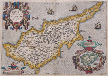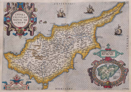
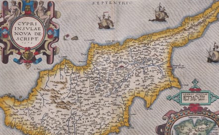
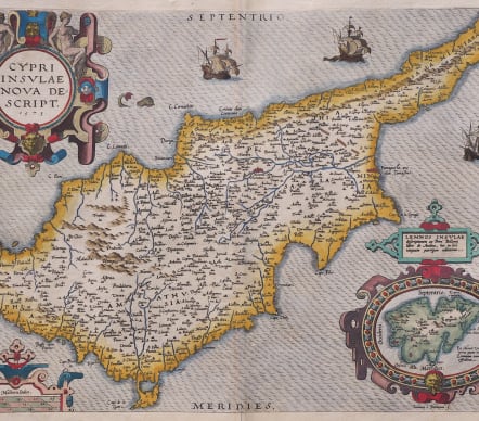
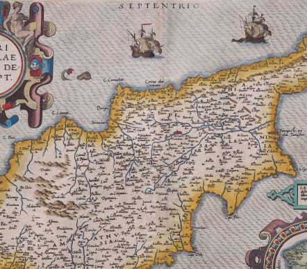
CYPRI INSULAE NOVA DESCRIPT 1573
£995
A beautiful example of the classic map of the island of Cyprus.
It was published by Abraham Ortelius in the ‘Theatrum Orbis Terrarum’ for the first time in 1573. It is drawn directly from the written account of the French naturalist Pierre Belon of 1553 and cartographically from Jacomo Franco’s map published in Venice c.1570, just prior to this map. Franco’s map improved the general outline of the island and provided more place names than any other before it. This Ortelius map is the earliest derivative of it and is engraved by Jan van Deutecum on a larger scale. It is augmented with three sailing ships, a fine sea monster and three ornate cartouches. One of these encloses an inset map of the island of Lemnos. Ortelius’ map had a great influence on the future cartography of Cyprus.
Excellent hand colour
Very good condition
From: Ortelius A. Theatrum Orbis Terrarum Antwerpen, Plantin Press, 1584. (Van der Krogt 3, 1:041)
References: Stylianou - 65 (fig.67); Van der Krogt 3 -
code : M5554
Cartographer : Ortelius Abraham
Date : 1584 Antwerp
Size : 35*53 cms heet 40*52.5 cms
availability : Available
Price : £995
From about 1560, possibly as a result of his friendship with Mercator, Ortelius began to produce maps - an eight sheet world map being the earliest. At this time, Ortelius also began preparing his greatest project, the Theatrum Orbis Terrarum. Having already become probably the greatest cartographic bibliographer of the period, Ortelius was able to prepare 53 map sheets based on the most up-to-date information, which were engraved by Frans Hogenberg, and first published in 1570.
The atlas achieved instant fame as "the world's first regularly produced atlas" (Skelton), being the first atlas with maps prepared to a uniform format. It was also an immediate commercial success, being reprinted four times in 1570. . Over 30 different editions, with text in Latin, French, Dutch, German, Italian, English or Spanish, testify to the popularity and esteem attributed to the work. Marcel Van Den Broecke, whose fascinating work on Ortelius and his maps is often quoted, estimates that around 7300 complete atlases were published using a total of 234 copperplates, either replacements or reworkings as plates became out-dated, worn, or as new information became available. Amongst this latter category, the maps added in the 1580's and 90's of the world, the Americas, China, the Pacific, Japan, Peru and Florida, and Iceland are important historically and justly famous.The maps themselves are finely engraved, often very decorative and generally found with text on the reverse.
After Ortelius' death in 1598 the atlas continued to be printed and published by the Plantin Press. Between 1602 and 1609 it was published by Johann Baptist Vrients, who added a variety of fine maps including the very decorative large plates of England and Wales, and of Ireland. Publication reverted to the Plantin Press, under the control of the Moretus brothers, from 1612.
Although only the relatively unsuccessful atlases of De Jode and, ultimately, Mercator were published during the sixteenth century life of the Theatrum …, in 1607 Jodocus Hondius's issue of Mercator's Atlas ... with many newly prepared maps began to supersede Ortelius' work.
Ortelius's small Atlas The Epitome published from 1590 ran for many editions and was very popular.