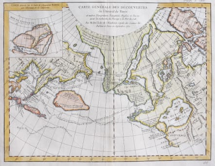
CARTE GENERALE DES DECOUVERTES DE L'AMIRAL DE FONTE
Sold
Attractive map of the North Pacific region.
This is one of the more remarkable combinations of fact and fiction ever published. This map of the North Pacific and Northwest had as its source a 1708 article in the Monthly Miscellany that purported to be a newly discovered account of a voyage in 1640 by the Spanish Admiral, Bartholomew de Fonte. Thereafter, the newly presented information was changed and elaborated upon, notably by this series of maps which appeared in Diderot's Encyclopedia. In its concept, it promoted the hopes of a Northwest Passage and depicts the existence of Mer de l'Ouest or the Sea of the West. The tracks for the Russian exploration in 1741 and other explorers are traced in the Pacific. Inset at upper left is a small map, "Carte dressee Sur la lettre de l'Amiral de Fonte par l'Ecrivain de la Californie" detailing the purported track of Admiral de Fonte.
San Francisco and Monteray marked on map.
Excellent hand colouir.
Very good condition.
code : M3210
Cartographer : DE L'ISLE Family
Date : 1752 / 1772 Paris
Size : 30*39 cms
availability : Sold
Price : Sold
Claude de l'Isle (1644-1720) was a geographer and historian working in Paris, but was overshadowed by his more famous son, Guillaume (1675-1726), who is probably the greatest figure in French cartography. Having learnt geography from his father, it is said that at the age of eight or nine he could draw maps to demonstrate ancient history. He studied mathematics and astronomy under J.D Cassini, where he received the grounding in scientific cartography, that is the hallmark of his work.
His first atlas was published in about 1700, in 1702 he was elected a member of the Academie Royale des Sciences, and in 1718 he became 'Premier Geographe du Roi'. His maps of the newly explored parts of the world reflect the most up-to-date information available and did not contain fanciful detail in the absence of solid information.
His work was important as marking a transition from the maps of the Dutch school, which were highly decorative and artistically-orientated, to a more scientific approach.
De L'Isle also played a prominent part in the recalculation of latitude and longitude, based on the most up-to-date celestial observations. His major contribution was in collating and incorporating this latitudinal and longitudinal information in his maps, setting a new standard of accuracy, quickly followed by many of his contemporaries. Guillaume De L'Isle's reputation was such that pirated versions appeared in many countries, most particularly by Chatelain and Covens and Mortier.
After his death in 1726 the business was continued by his nephew Philippe Buache, and subsequently by J. Dezauche.