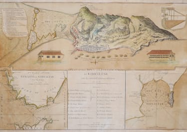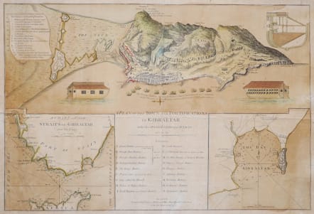
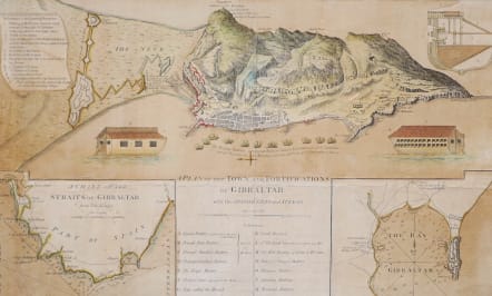
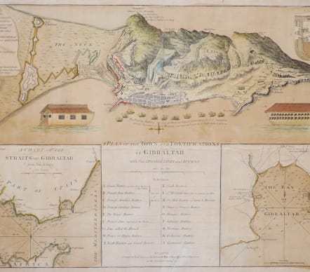
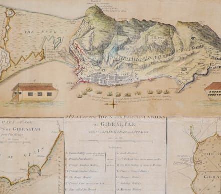
A PLAN OF THE TOWN AND FORTIFICATIONS OF GIBRALTAR WITH THE SPANISH LINES AND ATTACKS
£225
V RARE
First published circa 1779 and again in 1782, this fine plan and inset maps depict the British outpost at the beginning of the Great Siege of Gibraltar (1779-1783). The plan details the peninsula, a small reserve of British territory only 2.6 square miles in area, along Spain's Andalucía coast. As shown, it is dominated by the 'Rock of Gibraltar', a 1,400 tall limestone mountain, which is historically considered to be one of the Pillars of Hercules - the gates to the Mediterranean world.
The key at the center shows 18 different sites (labeled A-S). To the north, Fort St. Philip (Great Fort) and its bulwarks separate Gibraltar from Spain, then Britain's perennial nemesis.
Important map probably issued seperately.
Has repaired tears and is slightly scruffy. Lined professionally with Kozo 20grm mulberry archive paper.
Original colour
Fair condition for this rare map.
Published by Robert Sayer John Bennett London
https://gallica.bnf.fr/ark:/12148/btv1b84406808
code : M5509
Cartographer : SAYER & BENNET
Date : 1782 London
Size : 36*53 cms
availability : Available
Price : £225
Robert Sayer (ca. 1724-1794) was a prominent London map publisher. Robert’s father was a lawyer, but his older brother married Mary Overton, the widow of prominent mapmaker Philip Overton and the proprietor of his shop after his death. Mary continued the business for roughly a year after her marriage and then, in early 1748, it passed to Robert. Robert became a freeman of the Stationers’ Company later that year; his first advertisement as an independent publisher was released in December.
Sayer benefited from Overton’s considerable stock, which included the plates of John Senex. In the 1750s, Sayer specialized in design books and topographical prints, as well as comic mezzotints. In 1753, he, along with John Roque, published a new edition of Thomas Read’s Small British Atlas, the first of several county atlases that Sayer would publish.
Sayer’s business continued to grow. In 1760 he moved further down Fleet Street to larger premises at 53 Fleet Street. In 1766, he acquired Thomas Jefferys’ stock when the latter went bankrupt. In 1774, he entered into a partnership with John Bennett, his former apprentice. The pair specialized in American atlases, based on the work of Jefferys. They also began publishing navigational charts in the 1780s and quickly became the largest supplier of British charts in the trade.