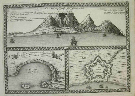
CAPETOWN CAP DE BONNE ESPERANCE
Sold
This map contains a well known view of the Cape of Good Hope and Table Mountain from the sea. The sheet also contains a map of Table Bay & Robin Island on the bottom left and a map of the Dutch Fort at Cape Town on the bottom right. The view of the Cape of Good Hope labels each mountain peak and contains a legend to identify important points in the town. Dutch flags fly atop one mountain and at the Fort. Ships sailing between Europe and the East Indies are in the harbor.
This map comes from de Fer's Atlas Curieux (Norwich). Tooley calls de Fer "a geographer, engraver, and published of considerable creative ability".
Very good condition.
Reference: Norwich map #211. Tooley, Map Collector's Guide to Africa, p. 45.
code : P1436
Cartographer : THEUNISZ Jacob
Date : 1705 Paris
Size : 25.5*36cms
availability : Sold
Price : Sold
The Theunisz firm of Amsterdam chartmakers was founded by Antonie Jacobz (Theunisz) (c. 1606 – 1650), who issued the first edition of the Zeespiegel in 1644. The enterprise operated under the name “Lootsman” (pilot) in order to avoid confusion with another printing company by the Theunisz name.