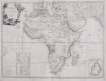
L'AFRIQUE DIVISEEEN SES PRINCIPAUX ETATS
£295
Excellent copper engraved map of the continent showing the extent of knowledge in the mid 18th century.
While mostly accurate, it does have remnants of fantasy such as the twin lake source of the Nile in the "Montagnes de la Lune, which in this depiction is quite a bit north of the Equator.
C. de Bonne Esperance and Stellembos Pic are the only settlements marked in southern Africa, which is occupied by the Hottentot tribes.
With 2 small inset maps of Cap de Bonne-Esperance and Isle de France. Ornamental title cartouche featuring palm trees and a lion in the upper left corner.
After Janvier.
Uncommon map in good condition
code : M3246
Cartographer : SANTINI Francois
Date : 1776 Venice
Size : 47.5*64.5 cms
availability : Available
Price : £295
Francois [Francesco] Santini was a Venetian map maker who re-issued the works of Robert de Vaugondy, Homann’s Heirs and De L’Isle. At this time, cartography in Italy was at a rather low ebb, so Santini, essentially a publisher rather than a map-maker modelled his work on two of the leading practitioners of cartography in Europe, the French map-makers Gilles and Didier Robert de Vaugondy. Their “Atlas Universel” was first published in 1758, and was much re-issued thereafter. The atlas was a commercial and cartographic success, with widespread influence on map-makers throughout Europe, most notably on Santini, who commissioned a new set of plates, published in 1776, being almost exact copies of the original French maps.