
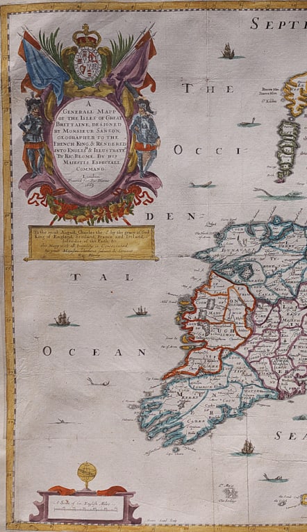


A GENERALL MAPP OF THE ISLES OF GREAT BRITTAINE DESIGNED BY MONSIEUR SANSON ..
£445
Full Title: A Generall Mapp of the Isles of Great Brittaine Designed by Monsieur Sanson, Geographer to the French King & Rendered Into English & Illustrated by Ric. Blome. By His Majestis Especiall Command
Rare and attractve map by Richard Blome based on Sanson's earlier map and engraved by Francis Lamb.
Decorative with attractive title cartouche and many ships and sea creatures.
Below cartouche is dedication 'To the most August Charles the 2d by the grace of God, King of England, Scotland, France, and Ireland, defendor of the Faith, &c. this Mapp with all humility is Concecrated by your Majesties Obedient Subject & Servant Ric. Blome.'
Very good hand colour .A near invisible repaired tear otherwise very good condition.
This is the first folio (and quite possibly the very first) world atlas wholly engraved, printed and published in England. http://www.mapforum.com/09/9blome.htm
Very Rare map
code : M4155
Cartographer : Richard Blome
Date : 1669 London
Size : 40*52 cms
availability : Available
Price : £445
Richard Blome (1641-1705) was an English publisher and bookseller who flourished from about 1670 to 1705. He published two series of English county maps. The large series appeared in Blome's Britannia, or a Geographical Description of the Kingdomes of England, Scotland and Ireland, with each map measuring approximately 300 x 250mm. The smaller series, with the maps approximately 240 x 180mm, were published in Blome's Speed's Maps Epitomiz'd: or the Maps of the Counties of England.
Blome also issued a world atlas, the Geographical Description of the Four Parts of the World, in 1670, which was re-issued as the Cosmography and Geography, in 1682 and 1693. The maps from this atlas were Anglicized copies of Nicolas Sanson's work. Blome also issued a number of Bible maps, usually after Visscher.


