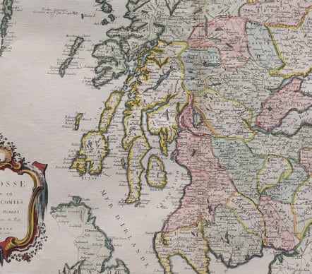
L'ECOSSE DIVISEE EN SHIRES ET COMTES
£265
Attractive folio map of Scotland after Vaugondy.
Striking and highly detailed copper engraved map of Scotland. Map includes also portion of Ireland. Map gives several details concerning cities, villages, rivers, lakes, mountains and islands. A large decorative title cartouche is in the lower left quadrant .
Strong impression
Excellent hand colour
Very good condition
From: Atlas Universel dressé sur les meilleures cartes modernes. Venice, Remondini, 1776.
code : M4951
Cartographer : SANTINI Francois
Date : 1778 Venice
Size : 49*57 cms
availability : Available
Price : £265
Francois [Francesco] Santini was a Venetian map maker who re-issued the works of Robert de Vaugondy, Homann’s Heirs and De L’Isle. At this time, cartography in Italy was at a rather low ebb, so Santini, essentially a publisher rather than a map-maker modelled his work on two of the leading practitioners of cartography in Europe, the French map-makers Gilles and Didier Robert de Vaugondy. Their “Atlas Universel” was first published in 1758, and was much re-issued thereafter. The atlas was a commercial and cartographic success, with widespread influence on map-makers throughout Europe, most notably on Santini, who commissioned a new set of plates, published in 1776, being almost exact copies of the original French maps.