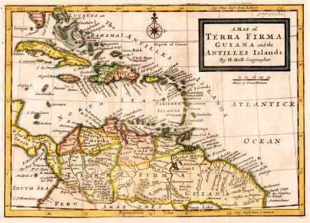
A MAP OF TERRA FIRMA GUINA AND THE ANTILLES ISLANDS
£145
Uncommon and quite detailed map
of the West Indies and northern South America by Herman Moll.
It covers from Florida to the the Amazon River. Includes the modern day countries of Colombia, Venezuela, Ecuador, Guyana and Brazil.
The city of Manoa and the location of El Dorao are also marked.
Finely engraved, a hallmark of Moll's work with a box cartouche and compass rose.
Excellent hand colour
Excellent condition
Published in London in Thomas Salmon`s "Modern History: or the Present State of All Nations
code : M4654
Cartographer : MOLL Herman
Date : 1740c London
Size : 18.5*25.5 cms
availability : Available
Price : £145
Herman Moll (1654? - 1732) was an important 18th century map publisher and engraver based in London and Holland
He moved to London in 1680 where he worked as an engraver for Moses Pitt, among other London map publishers. Around the turn of the century, Moll set up his own shop where he produced a large corpus of work known for its high quality and decorative flair.