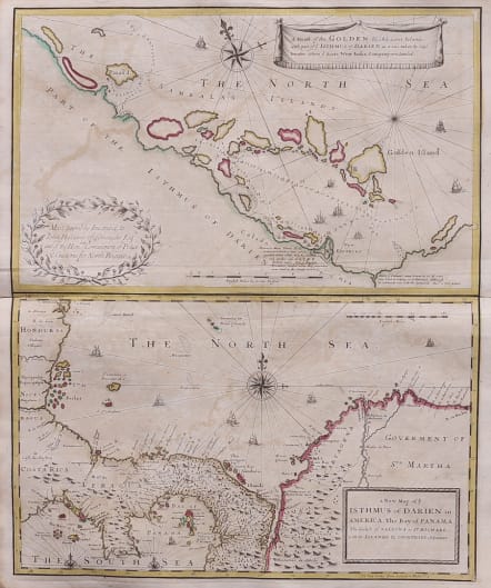
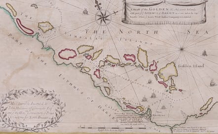
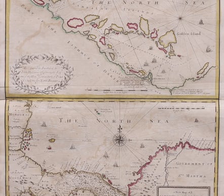
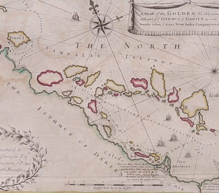
A DRAFT OF GOLDEN ISLAND .. WHERE SCOTS WEST INDIA COMPANY WERE SETTLED .. ISTHMUS OF DARIEN
Sold
Rare Map of Darien Isthmus and Scotland's West India Company New Edinburgh settlement.
Jenefer / Moll, engraver / John Senex, publisher], A Draft of the GOLDEN & Adjacent Islands, with part of ye ISTHMUS of DARIEN as it was taken by Capt. Jenefer, where ye Scots West-India Company were Setteled [sic] [on sheet with:] a New Map of ye ISTHMUS of DARIEN in AMERICA… [London, 1721.
The upper map depicts the Atlantic coast of modern-day Panama, known at the time as the Isthmus of Darien. The map emphasizes the advantageous location of New Calidonia [sic], blessed with a huge sheltered anchorage inshore of the Sambala Islands and an (apparently!) easy route across the isthmus to the Pacific and the riches of the East. A small note at lower right highlights the friendly nature of the native inhabitants: “Here ye Indians came down to us & were very kind in helping us to provision although in continual war with the Spaniards.” The lower map shows the colony in a broader regional context, with coverage extending to modern-day Colombia, Costa Rica, Nicaragua and Honduras. The map bears a dedication to John Haldane of Gleneagles, a Scottish lord and a director of the Company of Scotland, which organized the colonization effort.
The map was engraved in London by Herman Moll and originally published in 1699 by William Hacke and Robert Morden. Offered here is the second edition, which appeared in John Senex’ New General Atlas (1721). For this new edition Senex removed the Moll, Hacke and Morden imprints and changed the dedicatee from Lord John Sommers to John Haldane. The map was based on a manuscript by John Jenifer (fl. 1672-1699), who at one time served as a lieutenant on the HMS Guernsey. Jenefer was also the source for William Hacke’s Part of the Indian Empire of Darien in America (1686), a manuscript map held by the British Library (Catalog of the Manuscript Charts and Plans in the British Museum, p. 482).
In 1695 the Scottish Parliament chartered the “Company of Scotland Trading to Africa and the Indies,” its capital to be raised by public subscription. The Company’s primary venture was the “Darien scheme,” a new colony to be planted on the Isthmus of Darien for establishing trade with the Far East and the mineral-rich European colonies of South America. England actively worked against the Company, in an effort to protect the trade monopoly of its own East India Company and to avoid provoking Spain, which claimed the area as part of New Granada. As a result, the venture was funded entirely by the Scottish gentry and merchant and middle classes, ultimately absorbing a staggering 25 percent or more of the country’s liquid assets.
In 1698-99 roughly 3000 mostly Scottish colonists arrived in Darien. The colony was plagued by poor planning and leadership, lousy weather, lack of demand for trade goods, devastating epidemics and a shortage of food. Moreover the colony’s very existence was a provocation to Spain, and indeed it was abandoned after a siege by a Spanish force from nearby Cartagena. Only a few hundred of the original colonists survived to return home. The colony’s failure naturally lead to the collapse of the Company of Scotland, a devastating blow to the Scottish economy. It is generally accepted that this was a major contributor to the 1707 Act of Union between the badly-weakened Scotland and an ascendant England.
Original hand colour Slight offsetting usual on this map
Very good condition for this scarce and collectable rarity
References
Kapp, Early Maps of Panama, #27, state 2 (in Map Collector’s Series, vol. 8 no. 73). Phillips, List of Geographical Atlases in the Library of Congress, #563.34.
code : M4913
Cartographer : Senex J
Date : 1721 London
Size : 60*49 cms
availability : Sold
Price : Sold

