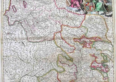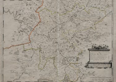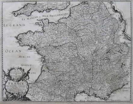
FRANCE CARTE GENERALE DU ROYAUME DE FRANCE
£250
Rare map of France by Sanson but published by Tavernier.This appears to be the first published edition of Sanson's map and is dated 1643 on the map.I can find very little information on this map and it might have been included in a later composite atlas.Some minor blemish in otherwise good condition.
Uncoloured as issued.
Nicolas Sanson (1600-1667) was born in Abbeville, where as a young man he studied history, particularly of the ancient world. At the age of 18 he was said to have compiled his first map. After he moved to Paris the King appointed him 'Geographe Ordinaire du Roi', one of his duties being to tutor the King in geography.
Melchior Tavernier was Paris most active publisher of prints and maps in the beginning of the 17th century. Sanson published his first separate map and atlas of France and Europe with Tavernier.
For unexplained reasons Melchior Tavernier retired trade in 1644.
code : M2591
Cartographer : SANSON Nicolas
Date : 1643 Paris
Size : 41*52 cms
availability : Available
Price : £250
Nicolas Sanson (1600-1667) is generally acknowledged as the founder of the great French school of geographers and cartographers that supplanted the Dutch as the leading European map-makers. His work was acclaimed for its geographical accuracy and high standard of engraving. As a consequence, his many maps received a wide diffusion. His career marks the start of the process by which Paris superseded Amsterdam as the centre of European map production.
Nicolas studied Ancient History as a young man, and this awoke in him an interest in classical geography. His first map, of ancient Gaul was made in 1618, when he was only 18. Sanson had three sons, Nicolas (1626-1648), Guillaume (d.1703) and Adrien (d.1708), and a grandson Pierre Moullard-Sanson (d.1730), all of whom were involved in the family’s map-making activities.
After Sanson settled in Paris his work came to the attention of King Louis XIII, who eventually appointed Sanson Geographe Ordinaire du Roi, one of whose duties was to tutor the King in geography. Sanson published some 300 maps in his career, though his first most famous atlas, the folio “Cartes Generales De Toutes Les Parties Du Monde” was not published until 1658. Sanson also prepared a series of quarto atlases of the different continents. These scarce atlases are more frequently encountered in the Dutch piracy, engraved by Anthony d’Winter, first published in 1683.
The Sanson atlases are rarely found with a standard set of maps; the practice seems to have been that additional, or revised, plates would be inserted as available. After Sanson’s death the business was continued by his two surviving sons and grandson, in partnership with, and later superseded by Alexis Hubert Jaillot.