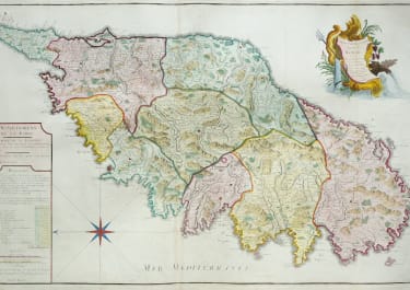
CARTE PARTICULIERE DE L'ISLE DE CORSE ..
£950
Full titlle : Carte Particuliere de L'Isle de Corse Divisée par ses Dix Provinces ou Juridictions et ses quatre Fiefs.
Stunning & beautiful large map of Corsica.
Originally published in about 1695 this is a later edition printed by Dezauche. Most of the later editions notably by Santini crops the north of the island so this is more pleasing keeping Corsica as a whole.
Legend regarding the ' departemans ' of Corsica left side with populations & total for the whole Island at 116,053.
Decorative title cartouche.
Excellent hand colour
The map is is in very good condition
REF: Cervoni, 62.1; Berthelot-Ceccaldi p. 147.
code : M5335
Cartographer : JAILLOT & COLLABORATORS
Date : 1695/ 1780 Paris
Size : 51*81 cms sheet size 56*83 cms
availability : Available
Price : £950
JAILLOT and reissues
Alexis Hubert Jaillot (c.1632-1712). In 1664 he married Jeanne Berey, the daughter of Nicolas Berey, the map publisher, and following the death of his father-in-law and his brother-in-law (also Nicolas), the business passed to Jaillot and he was to gain access to much of the stock.
On the death of Nicolas Sanson, his firm passed to his sons Guillaume and Adrien. They took Alexis Hubert Jaillot into partnership in 1671, now well-established at 'Aux Deux Globes', and he was to become second only to Sanson himself among the early school of French cartographers.
A number of Sanson's maps had been prepared but never published and others were in need of revision, so Jaillot began the process of preparing new maps on larger plates. These were published in the "Atlas Nouveau", published from 1681 onwards, although individual maps date from 1672.
After the break-up of his partnership with the Sansons, Jaillot joined with the Amsterdam publisher Pierre Mortier, who engraved virtually identical copies of these large maps, re-issued from 1692 onwards. In a similar vein, Mortier also copied the maps from Jaillot's "Atlas Francois" to be re-issued by him in the "Atlas Royal".
These Jaillot atlases, both in the French and Dutch versions, mark the end of the dominance of the flamboyant Dutch school of cartography, which was superseded by the more scientifically based French school. Jaillot exemplified the scientific approach of the French school, which was to reach full maturity in the next century under Guillaume de l'Isle and his heirs, and Jean Baptist d'Anville, who established France as the centre of European cartography.