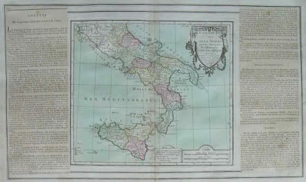
SOUTH ITALY SICILY ETATS DU ROI DES DEUX SICILES
£125
Attractive map of southern Italy and Sicily with ornamental rococo-style title cartouche.
The map is flanked by two columns of French text containing geographical information about the area. Map and border were printed from two separate plates with the text on glued down sheets, as issued.
Prepared by Louis Brion de la Tour and published by Louis Charles Desnos, active in Paris at rue St.Jacques.
Full original hand colour.Very good condition.
code : M2622
Cartographer : Louis Brion de la Tour
Date : 1766 Paris
Size : 33*51 cms sheet 25*27 map
availability : Available
Price : £125
Louis Brion de la Tour (1756-1823) was the Cartographer Royal to the King of France.
There is little information about his life. His official title was "King's Engineer Geographer." Although he is a prolific geographer, very little is currently known of his life or his career. His life was spent in scientific work. However what is known is an important part of his work was done in collaboration with Louis Charles Desnos (1750-1790 to) a bookseller and geographical engineer for the globes and spheres of His Danish Majesty.
His son Louis Brion de la Tour, a pupil of Jean-Bernard Restout, was engraver of maps and documents of the Revolution, and was also an occasional portrait oil paintings.