ETATS-UNIS DE L'AMERIQUE SEPTENTRIONALE AVEC LES ISLES ROYALE ...
£995
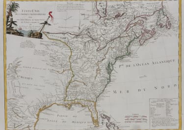
Etats-Unis De L'Amerique Septentrionale Avec Les Isles Royale, De Terre Neuve, De St. Jean, L'Acadie &c. 1785
Stunning map
Scarce early map of the newly created United States, published by Delamarche in Paris, shortly after American independence. The map appeared primarily in late editions of DeVaugondy's Atlas Universel, reissued by Delamarche.
The map is of particular note for being one of the earliest maps to illustrated the 10 new proposed states proposed by Thomas Jefferson--Silvania, Michigania, Chersonesus, Arsenistpia, Metropotamia, Illinoia, Saratoga, Washington, Polypotamia, and Pelisypia.
The United States is outlined in green, British territories appear in red, and Spanish lands in yellow. The United States extends westward to the Mississippi, beyond which Louisiana has been granted to Spain. So too has Florida and the French colonial seat of New Orleans.
The map is highly detailed, extending to the Rio Grande and including notes on the Sioux Indians and the Country of the Padoucas. Extensive notes throughout, including notes on early explorers such as De Soto and La Sale, Indians, Forts and other points of early interest.
Mississippi is marked as the western border, but the map extents till Mexico and naming "Tecas".
Good original outline colour plus later colour on cartouche.
Excellent condition for this sought after map.
References: Karpinski (MI) pp. 179-180, #CIII; McCorkle #785.5; Seller & Van Ee #187.
code : M5056
Cartographer : DELAMARCHE Charles Francois
Date : 1785 Paris
Size : 50*65 cms
availability : Available
Price : £995
Delamarche , Charles François
1740-1817
Founded by Charles François Delamarche who entered the globe industry as successor to the Robert de Vaugondy family of map and globe makers to King Louis XVI.
Delamarche obtained the shops of many of his local competitors, which enabled him to produce globe models in many different sizes. He also republished many Robert de Vaugondy maps and globes.
Charles worked with Charles Dien, a cartographer. In 1817 Felix Delamarche (1817-1847, son of Charles, took over the business which stayed in the family until 1847, when taken over by Grosselin.