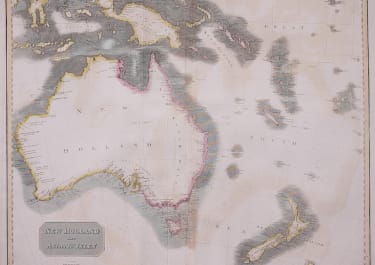
NEW HOLLAND AND ASIATIC ISLES
£285
Stunning important map published at the same time as Flinders famous map of 'Australia' - a name as yet not officially adopted, here the continent is referred to as 'New Holland' and "New South Wales'. Flinders' survey of the Australian coast is detailed here. Explorers mainly British are noted including Dampier, Cook, Bass & Flinders; Useful information such as 'No freshwater found here', 'This land is high and very barren', 'High trees, natives seen' etc. The interior remains unexplored and is left largely blank.
New Zealand's North & South Islands are named Fahino Mauwe and Tavai Poenammoo according to Captain Cook's adoption of the Maori names for the islands
Large format early map of Australia
Centre fold and 2 other folds professionally flattened
Good hand colour with slight toning
Generally very good condition
Better than the photo
code : M4310
Cartographer : John Thomson
Date : 1814 London
Size : 50*62 cms
availability : Available
Price : £285
THOMSON, John
flourised 1814-1869
John Thomson produced two major works in his life time, A New General atlas of the World 1814-28 and Atlas of Scotland 1820-32. The maps from A New General atlas of the World were printed in full hand coloring from large copperplate engravings. The level of detail at the time of publication was heralded as a breakthrough in British cartography and Thomson rightly earned a great deal of attention and his work copied for a number of years