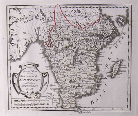
SOUTHERN SWEDEN SCHWEDEN
£125
Title: Spezial Karte von des Koenigreichs Schweden suedlichen Provinzen Nro. 68. Original copper engraving, hand colored in wash and outline, when published. The Austrian cartographer Franz Joh. Josef von Reilly published around 1789 in Vienna a large amount of very detailed district maps of Central Europe. These maps are famous for their large scales and the many details they provide. Even tiny place names can be found on those maps, rivers, mountains, streets, monasteries are as well engraved. The maps, which Franz J. Reilly engraved, were especially designed for the Austrian Royal house and show countries, provinces and districts belonging to the 'Austrian-Hungarian Empire'.Very good condition.code : M2147
Cartographer : REILLY VON Franz Johann Joseph
Date : 1791 Vienna
Size : 23*28cms
availability : Available
Price : £125
Austrian born Franz Johann Joseph von Reilly (1766-1820) produced over 830 maps for his great atlas project, "Schauplatz der funf Theile der Welt" between the years 1789 and 1806. Of these 830 maps published over this time span of seventeen years, he 'showcased' but one part of the world, Europe. Maps of the other four continents remained unpublished. The maps of the "Schauplatz ..."were drawn to a uniform criteria.
Reilly's "Grosser deutscher Atlas" was also notable as the first completely 'Austrian' atlas. This large world atlas, containing relatively few maps, was issued between 1794 and the end of 1796. Reilly may have used Franz Anton Schraembl's work as his model, at least in part.