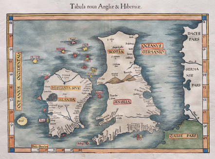
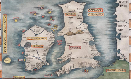
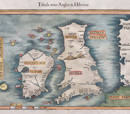
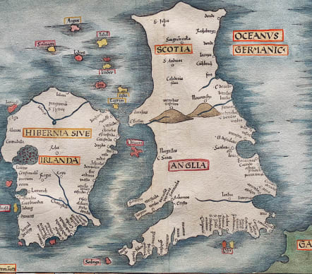
TABULA NOVA ANGLIAE & HIBERNIAE
Sold
Superb example of the Wäldseemüller Fries modern map of the British Isles.
This superb woodblock map is a reduced size version of Waldseemuller's modern map of the British Isles. Waldseemuller based his map on Italian portolan charts, although not necessarily from the most up-to-date charts. The principal cities and rivers are located, as well as a large mountain range between England and Scotland. The majority of the place names appear on the south coast of England, which had been more visited by mariners at the time. Ireland is shown pear-shaped with the "purgatorium of S. Patrick" labeled in the north. To the west of Ireland is the mythical island of Brazil, which continued to appear on maps for over 100 years. This map is from the same woodblock used for the 1522, 1525 and 1535 editions. It was printed by Gaspar Treschsel in Vienne, and is sometimes called the Lugduni-Vienne edition.
Excellent hand colour
Very good condition
References: Karrow, 28/30; Shirley (BI to 1650), 31.
From: Claudii Ptolemaei Alexandrini geographicae enarrationis libri octo. Lyon, M. Servetus, 1541. (Karrow, 288/G.3)
The editor of this edition, Michael Villanovus (better known as Servetus), was tried for heresy in 1553. He was burned at the stake, and at Calvin's orders, many copies of Servetus's books, including this one, followed him into the flames.
code : M4715
Cartographer : FRIES Lorenz
Date : 1522/ 1541 Vienne
Size : 30.5*41.5 cms
availability : Sold
Price : Sold
Laurent Fries (*1485 - †1532)
Laurent Fries was a French physician and mathematician born around 1485 in Mulhouse. He settled finally in Strassburg where he meat Peter Apian and the publisher Johannes Grüninger which made him interested in the Ptolemy Atlas of 1513 and 1520. Fries made new woodcut maps in reduced size. His Ptolemy Atlas was published first in 1522, reissued in 1525, 1535 and 1541. He died in 1532.