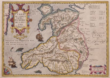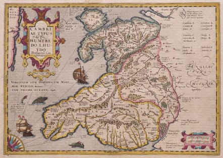
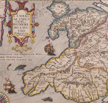
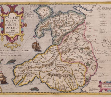
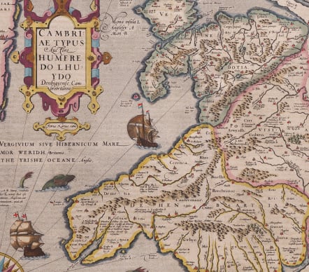
CAMBRIAE TYPUS HUMFREDO LHUYDO
£500
Superb original colour example of Mercator's map of Wales, the second printed map of Wales, after Ortelius' map of the same title, published in 1570.
The map is based on the map of Humphrey Lhuyd from 1568 as well as Mercator's 8-sheet wall map of the British Isles circa 1564. It is filled with details of mountain ranges, forests, and cities and also shows the coast of Ireland with Dublin located. It is beautifully embellished with decorative title and scale of miles cartouches, a large ship, and two sea monsters. French text verso.
Full unblemished margins.
Excellent original colour
Very good condition
Engraver: Petrus Kaerius
References: Van der Krogt 1, 5500:1A.1.
Publication Gerardi Mercatoris, Atlas sive Cosmographicae Meditationes de Fabrica Mundi et Fabricati Figura". Published in Amsterdam 1613. Engraved by Petrus Kaerius
code : M5508
Cartographer : GERARD MERCATOR
Date : 1613
Size : 35*50 cms sheet size 45.5*55.5 cms
availability : Available
Price : £500
Gerard MERCATOR
Originally a student of philosophy Gerard Mercator (1512-1594). He became an expert in land surveying and cartography, as well as a skilled engraver.His first maps were published in 1537 (Palestine), and 1538 (a map of the world), although his main occupation at this time was globe-making. He later moved to Duisburg, in Germany, where he produced his outstanding wall maps of Europe and of Britain. In 1569 he published his masterpiece, the twenty-one-sheet map of the world, constructed on what is now known as Mercator's projection.
It was during this period, while teaching cosmography at Duisburg, that Mercator realised the pressing need for a modern collection of maps to supersede the Ptolemaic atlases. This project was gradually expanded to be a complete description of the Universe, both heaven and earth, with other volumes on the Creation, Genealogy and History and a Chronology. The description of the earth was to be in two parts, a modern geography and a Ptolemaic atlas, a massive and over-ambitious project. In fact, only the Chronology and the Ptolemaic Geographia were completed in his lifetime, and it was left to his son, Rumold, to complete and publish the world atlas in 1595. Entitled Atlas, sive Cosmographicae Meditationes de Fabrica Mundi, this was the first time the name "Atlas" was applied to a bound collection of maps, and, like Mercator's projection, has remained in everyday use to this day.
After Rumold's death in 1599, the plates for the atlas were published by Gerard Jr. Following his death in 1604, the printing stock was bought at auction by Jodocus Hondius, and re-issued well into the seventeenth century.
The Atlas Minor was reprinted,reengraved by many 16th century Dutch cartographers including Cloppenberg, Jansson etc.