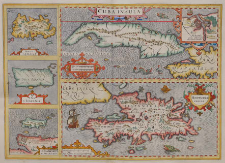


CUBA INSULA HISPANIOLA INSULA
£595
Cuba Insula [with] Hispaniola Insula [with] Insula Jamaica [with] Ins. S. Ioannis [with] I.S. Margareta Cum Confiniis
Stunning antique map of the Cuba and the Antilles by G. Mercator and J. Hondius
This, composite map of important islands in the West Indies is presented with two large maps of Cuba and Hispaniola, and smaller maps of Jamaica, Puerto Rico and Isla Margarita along the left side. The map of Cuba includes an inset plan of Havana. The map is richly embellished with a variety of sea monsters, a flying fish, sailing ships and strapwork cartouches.
The main map Cuba has an inset: “Havanna”.
Attractive map with good detail for 1606. Inset map of Havana
Cartouches, sailing ships and sea monsters.
Excellent hand colour.
Mint condition
References: Van der Krogt 1, 9610:1A.
From: Gerardi Mercatoris – Atlas sive Cosmographicae Meditationes de Fabrica Mundi et Fabricati Figura. Amsterdam, J. Hondius, 1619. (Van der Krogt 1, 113)
code : M5102
Cartographer : GERARD MERCATOR
Date : 1606 / 1616 Amsterdam
Size : 36*50 cms plus margins
availability : Available
Price : £595
Gerard MERCATOR
Originally a student of philosophy Gerard Mercator (1512-1594). He became an expert in land surveying and cartography, as well as a skilled engraver.His first maps were published in 1537 (Palestine), and 1538 (a map of the world), although his main occupation at this time was globe-making. He later moved to Duisburg, in Germany, where he produced his outstanding wall maps of Europe and of Britain. In 1569 he published his masterpiece, the twenty-one-sheet map of the world, constructed on what is now known as Mercator's projection.
It was during this period, while teaching cosmography at Duisburg, that Mercator realised the pressing need for a modern collection of maps to supersede the Ptolemaic atlases. This project was gradually expanded to be a complete description of the Universe, both heaven and earth, with other volumes on the Creation, Genealogy and History and a Chronology. The description of the earth was to be in two parts, a modern geography and a Ptolemaic atlas, a massive and over-ambitious project. In fact, only the Chronology and the Ptolemaic Geographia were completed in his lifetime, and it was left to his son, Rumold, to complete and publish the world atlas in 1595. Entitled Atlas, sive Cosmographicae Meditationes de Fabrica Mundi, this was the first time the name "Atlas" was applied to a bound collection of maps, and, like Mercator's projection, has remained in everyday use to this day.
After Rumold's death in 1599, the plates for the atlas were published by Gerard Jr. Following his death in 1604, the printing stock was bought at auction by Jodocus Hondius, and re-issued well into the seventeenth century.
The Atlas Minor was reprinted,reengraved by many 16th century Dutch cartographers including Cloppenberg, Jansson etc.