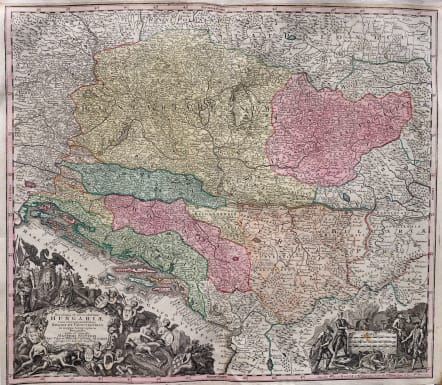


NOVISSIMA ET ACCURATISSIMA HUNGARIAE
£385
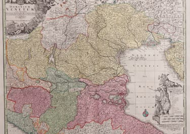
"Novissima et accuratissima Hungariae cum circumjacentibus in Mappa Geographica"
This superb detailed and attractive map. The map has Belgrad almost in the centre. In the upper right is some of Poland and Moldavia. The pink area on the right side is Transylvania. The pink area in the lower left is Bosnia. The upper light yellow area is Hungary as it was at the time.
Two of Seutters typically large cartouches.
The one in the lower left is very decorative. Cherubs hold the various coats-of-arms.
Above this cartouche is part of the coast of Croatia and Dalmatia. In the lower right is another decorative cartouche with a hunting scene.
Excellent Original wash colour
Very good condition
code : M4736
Cartographer : SEUTTER Family
Date : 1728 Augsberg
Size : 50*18.5 cms
availability : Available
Price : £385
Besides the Homanns, the other great German publishers of the eighteenth century were the Seutter family. Mattheus Seutter the elder (1678-1757) was apprenticed to Johann Baptist Homann in 1697 in Nuremberg, but left to settle in Augsburg where he established his own business publishing atlases, including the "Atlas Geographicus" (1725) and "Grosser Atlas" (circa 1735). Seutter's style was heavily influenced by Homann, with distinctive similarities appearing in his maps. He was joined in the business by his son, Albrecht (1722-1762), who continued the firm in partnership with Tobias Conrad Lotter (1717-1777) on his father's death.